


Help support this site by using our Amazon or Six Moons Design buttons for any purchase
Links with comments
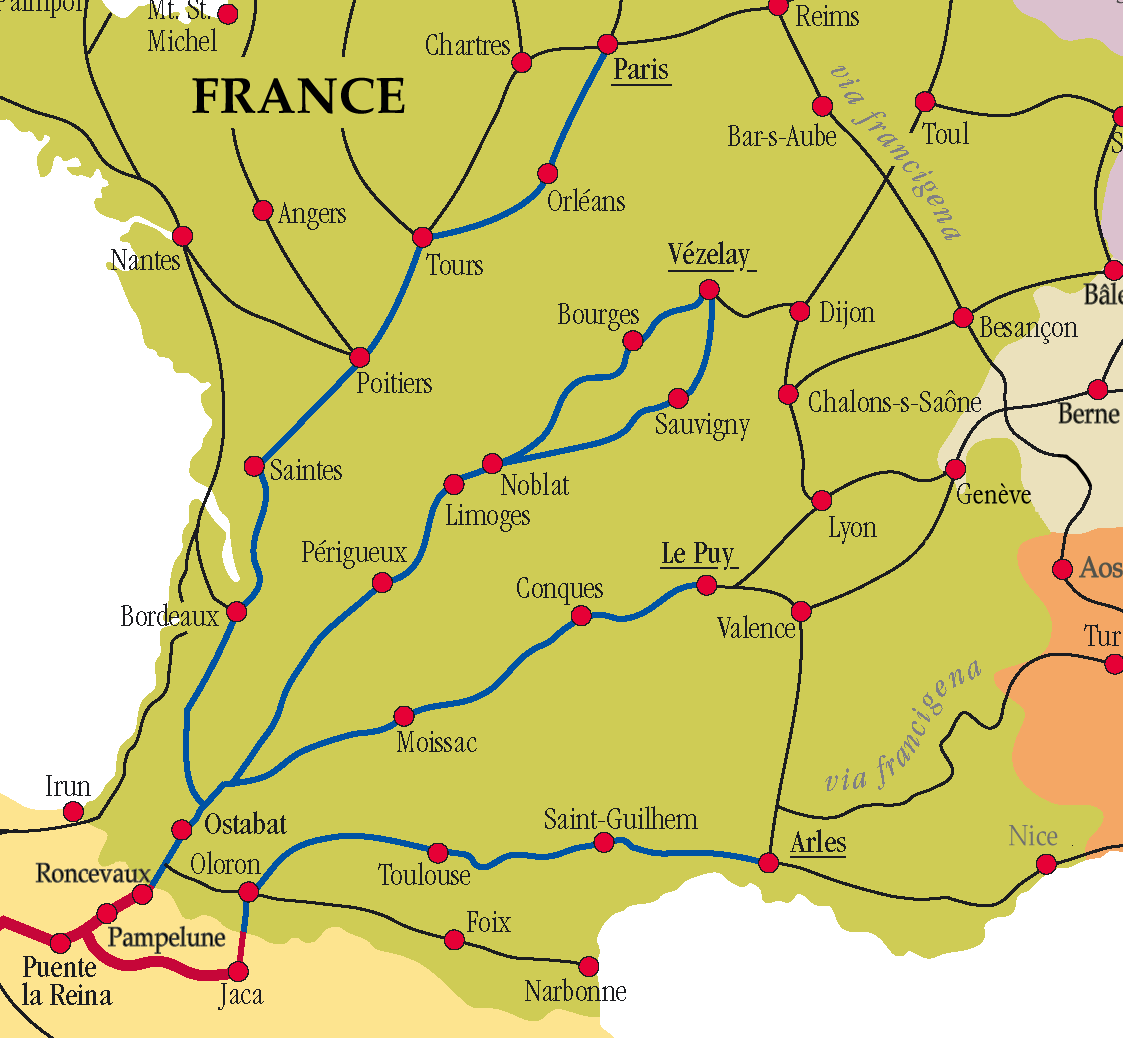
We walked about 130 miles of this route (via Nevers) in spring 2017, another 130 in 2018 to Limoges and 175 in 2019 to Bazas. Plan to finish in 2020. We are storing the info here as we collect it. The map above is excepted from Wikipedia.
It was very quiet on our 2017 trip - saw 4 pilgrims on the trail in two weeks. Stayed in two pilgrim accommodations where we were the only ones in the building. The terrain is the easiest of any route we have been on (many - Le Puy, Arles and more). After Nevers it remained fairly easy until the routes joined. At that point we had to pay close attention to route finding. The Miam Miam Dodo amazon.fr/Miam-Miam-Dodo-Vézelay-branches-variante-Bergerac/dp/2916446834/ is best for food and accommodations, but the essential guide for day to day walking and distances is the Dutch guide (a version is published in English). They are also sometimes available on the Confraternity of St. James bookstore, but check the edition.
The starting point for the Dutch guide is the English version of their site. www.santiago.nl/english/vezelay-main-page The guides and accommodation lists can be downloaded as pdfs: www.santiago.nl/english/guides-as-pdf-files
Look at Amis et Pèlerins de Saint-Jacques de la Voie de Vézelay.
www.vezelay-compostelle.eu. In French.
Use Google Translate if needed. This association of friends of the route
maintains three shelters along the way - Sanctuary Ainay-le-Château, Bouzais and Saint-Ferme,
open during the pilgrim season of March 15 to October 15. A pilgrim credential is required. One night stay
and out by 8:30 am is the normal rule. Clicking a leg on their map will reveal pdfs
with detailed turn by turn information on route and accommodations for that leg. For example: www.vezelay-compostelle.eu/pdf/32-tracesEN/20180822181659.pdf . The first part of the pdf has the detailed route directions, and a summary line on food and lodging. At the
back of the pdf there is an itemized list of all food and lodging, in order by km from start. For example:
ISSOUDUN 36100 km 13 cumul tronçon : 39 km
AHR Missionnaires du Sacré Cœur, Centre international Jules Chevalier
38 place du Sacré Cœur
tél : 02.54.03.33.83
(prévenir).
HR Les Trois Rois Hôtel de France et du Commerce**
3 rue Pierre Brossolette
tél
: 02.54.21.00.65
HR Hôtel de la Gare** Restaurant La Locomotive
7 boulevard Pierre Favreau
tél : 02.54.21.11.59
This site covers the beginning 300 km of the route, from Vézelay to Gargilesse. You have two choices here, The Northern route through Bourges or the Southern route through Nevers. They join at Gargilesse. This site's route is more historically correct, but the GR 654 has the same destination and less tarmac. I've looked at several maps of this part of the Vézelay Route and they each seem to have different towns identified on the Northern and Southern Routes. An example is the Wikipedia map at the top of this page vs the Amis et Pèlerins map. When you zoom in on the Peter Robbins maps below, you see multiple trails, intertwining their way South.
Peter Robbins map site - had maps right down to the topographic level. At a high zoom, they showed the trails. Has been moved to github and not updated for several years, but sometimes useful: for all pilgrim trails - pilgrimdb.github.io/limoges.html. He lists the Vézelay route as Via Lemovicensis. After looking at this I think every day requires heavy map use, and a gps or equivalent smart device is needed.
For the next 152 km South, or 87 km, depending on your varient choice, use www.compostelle-limousin-perigord.fr/html/lechemin.html
If you are on Facebook, the Vézelay group is an important resource. Be sure to join it: Way of St. James--Voie de Vezelay--Camino de Santiago
Ivar's caminosantiago.me is an excellent resource and Jacques-D had a very useful
reply on this thread:
www.caminodesantiago.me/community/threads/aloha-and-where-can-i-find-maps-of-the-vezelay-route.22376/.
Jacques supplied the links for all the associations along the Vézelay route. He said what remains of the guide Chassain is in these links. (for example that pdf link I had earlier).
Vézelay to Eguzon: www.vezelay-compostelle.eu
Eguzon to La Coquille: missing...
La Coquille to Port-Sainte-Foy: www.compostelle-limousin-perigord.fr
Port-Sainte-Foy to Captieux: www.saint-jacques-aquitaine.com/voie_vezelay.php
Captieux to Hagetmau: www.compostelle-landes.org/index.php?p=vezelay&lng=en
Hagetmau to St-Jean-Pied-de-Port: www.aucoeurduchemin.org/spip/spip.php?rubrique382
Emma Gatewood first hiked the entire 2160 mile Appalachian Trail at the age of 67. She last hiked it at the age of 76.
Page Changed: February 1, 2020 16:20
[Home][Top of Page] -
Please send comments, suggestions to backpack45 circleatsign yahoo dot com
All
text and images copyright © Shepherd Canyon Books - 2003 through 2020
“backpack45.com is a participant in the Amazon Services LLC Associates Program, an
affiliate advertising program designed to provide a means for sites to earn
advertising fees by advertising and linking to amazon.com”
